truestar inc. point every year
Summary
This dataset is a processed by truestar, based on the land price public announcement data from the Ministry of Land, Infrastructure, Transport and Tourism’s National Land Numerical Information.
Sample Data
Please select the table you’d like to view from the Snowflake Marketplace data dictionary.
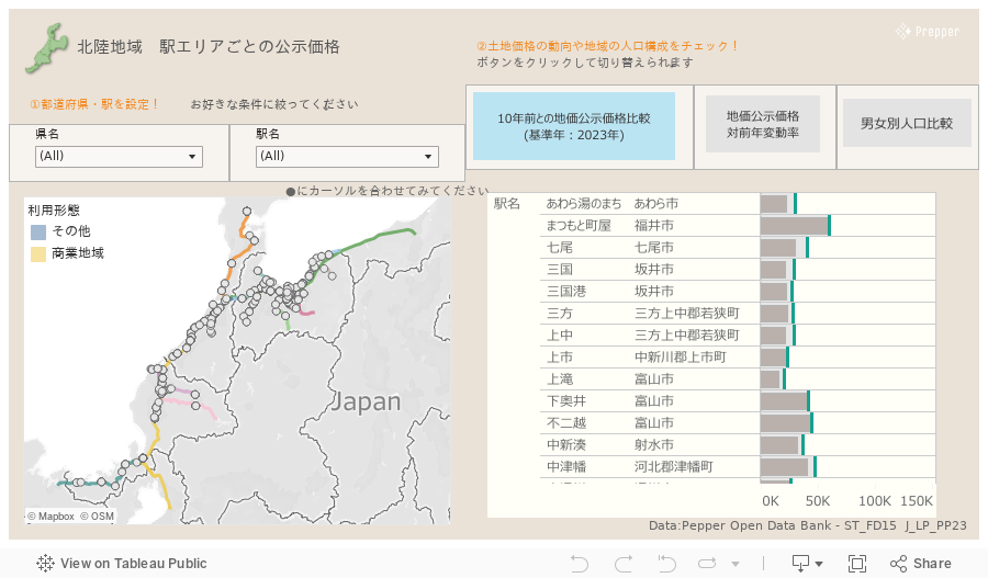
Click here for sample data from Japanese Land Price Data
Features/Usages
The land price data is published by the Ministry of Land, Infrastructure, Transport and Tourism as a reference for land transaction prices, determining and announcing the price per square meter as of January 1st of each year. This dataset contains time-series land price information and the latest property information for approximately 26,000 locations throughout Japan, making it possible to compare among locations. As with raw data, time-series information is also horizontally arranged in one record.
Similar to the raw data, the dataset that stores time-series land price data in a wide format (one record per location) is provided as Japan Official Land Price (LP_PP).
Meanwhile, the dataset that stores time-series land price data in a long format (one record per year per location) is provided as Japan Official Land Price – Time Series (LP_TS).
These two datasets can be joined using the column PODB_LAND_PRICE_ID as a key.
Please note that due to the structure of the data, all property data for the land associated with each year’s record will be the latest year’s data when merged.
Latest version: LP_PP
Anual versions: LP_PP25, LP_PP24… (suffix = last 2 digits of year)
Data Fields
| PODB_LAND_PRICE_ID | |
| RLC_INDEX | |
| RLC_USE_DISTRICT | |
| RLC_SEQ | |
| PRE_RLC_INDEX | |
| PRE_USE_DISTRICT | |
| PRE_RLC_SEQ | |
| RESEARCH_YEAR | |
| POSTED_LAND_PRICE | |
| VOLATILITY_OVER_THE_PREVIOUS_YEAR | |
| AC_SELECTED_LAND_STATUS | |
| AC_ADDRESS | |
| AC_ACREAGE | |
| AC_CURRENT_USE | |
| AC_BUILDING_STRUCTURE | |
| AC_SUPPLIED_FACILITY | |
| AC_DISTANCE_FROM_STATION | |
| AC_USE_DISTRICT | |
| AC_FIRE_AREA | |
| AC_URBAN_PLANNING_AREA | |
| AC_FOREST_LAW | |
| AC_PARKS_LAW | |
| AC_BUILDING_COVERAGE | |
| AC_FLOOR_AREA_RATIO | |
| RLC_CITY_NAME | |
| LOCATION | |
| ADDRESS | |
| ACREAGE | |
| PRESENT_USAGE | |
| USAGE_DESCRIPTION | |
| USAGE_CLASSIFICATION | |
| BUILDING_STRUCTURE | |
| GAS_FACILITY | |
| WATER_FACILITY | |
| SEWAGE_FACILITY | |
| CONFIGURATION | |
| FRONTAGE_RATIO | |
| DEPTH_RATIO | |
| NUMBER_OF_FLOORS | |
| NUMBER_OF_BASEMENT_FLOORS | |
| FRONTAL_ROADE | |
| DIRECTION_OF_FRONTAL_ROAD | |
| WIDTH_OF_FRONTAL_ROAD | |
| STATION_SQUARE_OF_FRONTAL_ROAD | |
| PAVEMENT_OF_FRONTAL_ROAD | |
| SIDE_ROAD | |
| DIRECTION_OF_SIDE_ROAD | |
| SURROUNDING_PRESENT_USAGE | |
| STATION_NAME | |
| PROXIMITY_WITH_TRANSPORTATION_FACILITY | |
| DISTANCE_FROM_STATION | |
| USE_DISTRICT | |
| FIRE_AREA | |
| URBAN_PLANNING_AREA | |
| ALTITUDE_DISTRICT | |
| FOREST_LAW | |
| PARKS_LAW | |
| BUILDING_COVERAGE | |
| FLOOR_AREA_RATIO | |
| EXTRA_FLOOR_AREA_RATIO | |
| COMMON_SURVEYED_POSITION | |
| SELECTED_YEAR | |
| LP_1983 〜 LP_2026 | |
| AC_1984 〜 AC_2026 | |
| PREF_CODE | |
| PREF_NAME | |
| PREF_CODE_NAME | |
| CITY_CODE | |
| CITY_NAME | |
| CITY_CODE_NAME | |
| POINT_LAND_PRICE |
References
Digital National Land Information (Ministry of Land, Infrastructure, Transport and Tourism)
https://nlftp.mlit.go.jp/ksj/gml/datalist/KsjTmplt-L01-2026.html
Prepared by truestar based on information from the above source.
Tableau Usages