
truestar, inc. Point & Polyline every year
Summary
This dataset includes the station point and polyline data, which is edited by truestar based on the railway data of Digital National Land Information provided by MLIT – Ministry of Land, Infrastructure, Transport and Tourism.
Sample Data
Features/Usages
We set the point and polyline data of national railway lines or stations to be one record for each “institution type”, “operation company”, and “station name”.
Some data sources of Digital National Land Information have multiple polylines for one station. However, for your convenience, we integrated them to be one record when the institution type and the operation company are the same. Since the original data don’t have the point data of stations, we defined the central coordinate of the integrated polyline data as the point data of stations.
You can easily identify the nearest station or calculate the distance if you try the spatial join with other datasets which are released at Snowflake Data Marketplace.
For your information, we deleted the railway line name from this dataset since it is often different between the generic term and the official term. If you need “railway line name”, you can use “POINT_STATION_01”.
Data Fields
| RESEARCH_DATE |
| RAILWAY_CLASS |
| INSTITUTION_TYPE |
| OPERATION_COMPANY |
| STATION_NAME |
| LONGITUDE |
| LATITUDE |
| PREF_CODE |
| PREF_NAME |
| PREF_NAME_EN |
| PREF_CODE_NAME |
| CITY_CODE |
| CITY_NAME |
| CITY_CODE_NAME |
| POLYLINE_STATION |
| POINT_STATION_CENTROID |
| POLYLINE_RAILWAY |
References
Edited by truestar based on the following data:
the railway data, which is cited from Digital National Land Information provided by MLIT
https://nlftp.mlit.go.jp/ksj/gml/datalist/KsjTmplt-N02-v2_3.html
regional data of Digital National Land Information provided by MLIT (as of Jan.1st 2021)
https://nlftp.mlit.go.jp/ksj/gml/datalist/KsjTmplt-N03-v3_0.html
Special Notes
1/ Regarding railway line names:
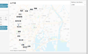
Mainly in JR, what is generally used as a line name is the operation system name. This name is different from the line name of the railway data published in the National Land Numerical Information, which requires careful consideration when being deployed. For example, the Yamanote line in fact includes 30 stations forming a ring shape such as Tokyo station and Shinbashi station, however only stations from Shinagawa to Tabata are registered. Other stations are registered in other lines, for instance Kanda station in Chuo line, Akihabara station in Soubu line, Ueno station in Touhoku line, etc., which is difficult to understand for normal users.
Therefore, Prepper Open Data Bank (hereinafter referred to as PODB) has prepared two datasets, one that retains the route name (POINT_STATION_01) and one without the route name (POINT_STATION_02). We hope users may have the freedom to choose either dataset which fits their own needs.
When deploying both station and railway section data, please use either of the following combinations:
“POINT_STATION_01” and “POLYLINE_RAILWAY_01”
or
“POINT_STATION_02” and “POLYLINE_RAILWAY_02”.
2/ Regarding station’s polyline data:
Polyline station is the polyline of station platforms in the pre-processed data.
In the railway data published in National Land Numerical Information, several station polylines may be linked to one station.
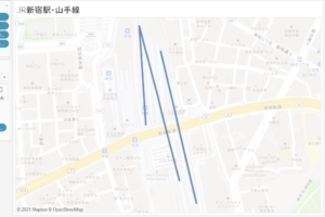
The following map shows the polylines of Shinjuku station.
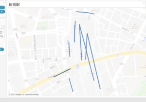
In POINT_STATION_01 【日本の駅(路線名あり)】, data are recorded in the unit of:
・Institution Type【事業者種別】
・Operation Company【運営会社】
・Railway Line Name【路線名】
Several station polylines of the same railway line are combined into 1 station record.
“Polyline of Shinjuku Station on the Yamanote Line of East Japan Railway Company (JR East) in POINT_STATION_01”
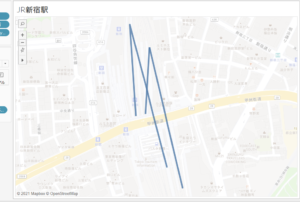
In POINT_STATION_02 【日本の駅(路線名あり)】, data are recorded in the unit of:
・Institution Type【事業者種別】
・Operation Company【運営会社】
Several station polylines of the same operation company are combined into 1 station record.
“Polyline of Shinjuku Station of East Japan Railway Company (JR East) in POINT_STATION_02”
3/ Regarding station’s point data:
Since National Land Numerical Information does not contain point data of stations, we have created a representative point for each station by using the center point of station’s polyline for convenience. Therefore, when multiple target polylines exist in a station, the case in which a station’s representative point indicated by its polyline data does not fall in the station’s platforms. (Figure below)
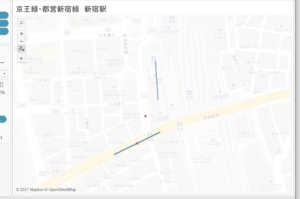
The polyline at the right bottom of the figure is where the Keio line and the Toei Shinjuku line overlap, and the central point becomes that of the Toei Shinjuku line.
Since there are two polylines on the Keio Line, the representative point is displayed at the midpoint between them, which is off the polyline.
In addition, for attributes of prefectures and cities, wards, towns, and villages linked to station data, we do not have official information from open data; therefore, they were determined by using the location information of station points created by us. Please note that these data may not match the information published in some records.
Update History
- 2022/1/28 : Rename JAPAN_POINT_STATION_02 to POINT_STATION_02